Thursday, November 7, 2013

PAGASA Weather Bulletin for Super-Typhoon Yolanda

The Philippine Atmospheric, Geophysical and Astronomical Services Administration (PAGASA) released the latest weather bulletin for Super-typhoon Yolanda at 11:00 AM. The PAGASA Weather Bulletin contains weather data obtained around 10:00 in the morning.

According to the PAGASA weather bulletin, the eye of Typhoon Yolanda was located about 637 kilometers East of Hinatuan, Surigao Del Sur or 738 kilometers Southeast of Guiuan, Eastern Samar or at approximate position 8.9°N., 132.1°E.

According to PAGASA’s hourly updates, Typhoon Yolanda is at 644 km Southeast of Guiuan, Eastern Samar. This update was issued around 1:00 in the afternoon.

PAGASA weather bulletin further states that Typhoon Yolanda has maximum sustained winds of 215 kilometers per hour (kph) near the center and gustiness of up to 250 kph.

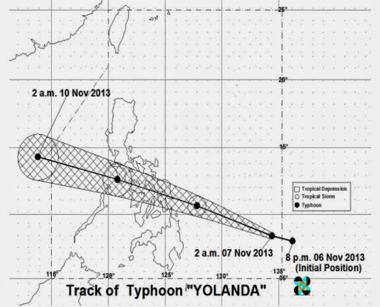
Here is the projected typhoon track from the PAGASA weather bulletin:

Typhoon track of Yolanda from PAGASA weather bulletin

PAGASA reports that the center of Typhoon Yolanda will hit Guiuan. The typhoon is expected to pass through the Philippines in roughly following order: Leyte, Biliran, Northern tip of Cebu, Iloilo, Capiz, Aklan, Romblon, Semirara Island, Southern part of Mindoro and Busuanga. It will exit the Philippine landmass on Saturday morning towards the West Philippine Sea.

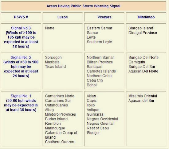
Here is the list of places in the Philippines that has Public Storm Warning Signal (PSWS) according to PAGASA.

Areas with typhoon signals according to PAGASA weather bulletin

For information about Typhoon Yolanda, please visit the PHIVOLCS website.
Saturday, November 2, 2013

Areas Affected by Big Earthquake of Marikina Fault Line

The earthquake that happened in Bohol last month is another eye-opener to Metro Manila citizens. We are as vulnerable as the Boholanos are. According to the Philippine Institute of Volcanology and Seismology (PHIVOLCS), a major fault line passes through Metro Manila. This fault line is the West Valley Fault or more popularly known as Marikina Fault Line.

Marikina Fault Line passes through the eastern part of Metro Manila. It passes through Marikina City, Quezon City, Pasig City, Taguig City, Muntilupa City and some towns in the Provinces of Rizal and Laguna. For maps affected by the Marikina Fault Line, please read my post PHIVOLCS Map of Marikina Fault Line Affected Areas.

Map of Marikina Fault Line from PHIVOLCS

PHIVOLCS, with the funding from Japan International Cooperation Agency (JICA), conducted a study on earthquake impact reduction for Metro Manila. The study contains information about the earthquake damage scenario for Metro Manila, damage estimation due to earthquake, and a master plan and action plans for safer Metro Manila.

Those who are interested in this research study should visit the Metro Manila Earthquake Impact Reduction Study (MMEIRS) page in PHIVOLCS website.

An interesting information that I saw in the MMEIRS is the map showing the areas that are most vulnerable if Marikina Fault Line will cause a very strong earthquake.

Map from PHIVOLCS showing areas that are highly vulnerable to Marikina Fault Line Earthquake

The areas encircled on the map corresponds to the areas listed in the study that is highly vulnerable to earthquakes caused by Marikina Fault Line. Here is the list as shown on the study made by PHIVOLCS.

PHIVOLCS list of areas that are highly vulnerable to Marikina Fault Line earthquake

The list shows that Navotas Bay Area, Western Marikina City Area, Manila North Port Area, Eastern Pasig City Area, South Eastern Manila City Area, Muntinlupa Laguna Bay Area, Central Manila Bay Area, Mandaluyong - Makati City Border Area, and North Eastern Quezon City Area are the most vulnerable areas.

The PHIVOLCS study also made a list of the type of vulnerabilities that the 9 high vulnerable areas may experience if Marikina Fault Line causes a big earthquake. Here is the list:

PHIVOLCS list classifying high vulnerable areas by type

The MMEIRS is very valuable since it gives us information of the areas that will be severely affected by a big earthquake. All residents of Metro Manila, especially those who are living in the 9 highly vulnerable areas, should keep in mind these information. Let us all prepare and be ready because it is just a matter of time before Marikina Fault Line will cause a big earthquake.

For more earthquake preparedness tips please read PHIVOLCS Tips on Being Prepared for Earthquakes and Tsunami.

Also read my posts regarding earthquakes and tsunamis: