Showing posts with label PHIVOLCS. Show all posts

Friday, August 22, 2014

PHIVOLCS' Marikina Fault Line Map for Alabang Area (Muntinlupa)

Earthquake is one destructive natural phenomenon. It can topple skyscrapers, bury whole community, and destroy a whole city in just few seconds. The problem is that the occurrence of earthquakes is cannot be predicted. All that we can do is prepare for it.

Preparing for earthquakes means getting as much information as you could regarding earthquakes. Good thing that the Philippine Institute of Volcanology and Seismology (PHIVOLCS) is active in its information campaign. Providing the Marikina Fault Line maps is part of that information campaign.

I posted about the index maps of the Marikina Fault Line. However, those are not adequate to answer the question of many readers of this blog. So, to help you and other people like you want to know more about the Marikina Fault Line I will be posting the detailed (large scale) Marikina Fault Line maps.

For this article, I will be posting about the Marikina Fault Line map in the Alabang area:

Marikina Fault Line Map - Alabang (Muntinlupa)

Based on this Marikina Fault Line map from PHIVOLCS, the fault line passes through the following areas:

Liberty Homes
New Alabang Hills Village
Capri Condominium
Pleasant Village
Lake View Homes
Freedom Hills

The red line on the above map indicates the location of Marikina Fault Line. Here is the explanation of the type of lines used in the map:

Legend for the symbols in Marikina Fault Line Map

The map that I posted here is just a portion of PHIVOLCS Marikina Fault Line map covering Alabang, Muntinlupa City. If you want to view the whole map, I suggest that you visit PHIVOLCS website for the Marikina Fault Line map in Alabang, Muntinlupa.

---

Be prepared for earthquakes! Know more about the Marikina Fault Line by visiting these articles:

PHIVOLCS Fault Line Map for Taguig City and Makati City

Areas Affected by Big Earthquake of the Marikina Fault Line
New Index Map of the Marikina Fault Line
Map of Areas Affected by the Marikina Fault Line
How to be Prepared for Earthquakes
.

Tuesday, July 29, 2014

New Index of Marikina Fault Line Map

I noticed that there is a new update to the website of the Philippine Institute of Volcanology and Seismology (PHIVOLCS). This update brought both good news and bad news not only to me but to everyone who wanted to get plenty of information about the West Valley Fault, or more popularly known as the Marikina Fault Line.

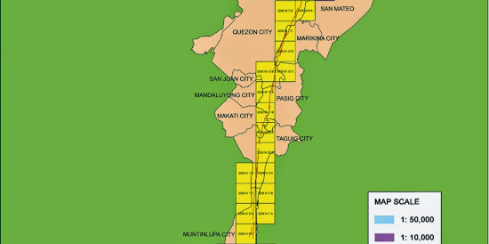
The good news is that they replaced the old index for Marikina Fault Line maps (which you can check on this blog post) with a better looking one:

Marikina Fault Line Map - top
Marikina Fault Line Map - middle
Marikina Fault Line Map - bottom
Index of Marikina Fault Line map (Source: PHIVOLCS website)


The new index map is colorful and gives a clearer overview of the areas affected by the Marikina Fault Line.

The new index map shows that the Marikina Fault Line passes through the Bulacan towns of Doña Remedios Trinidad, Norzagaray, and San Jose Del Monte City; Rizal town of Rodriguez (Montalban);  Metro Manila cities of Quezon, Marikina, Pasig, Makati, Taguig, and Muntinlupa; Laguna towns of San Pedro,  Biñan, Santa Rosa City, Cabuyao, and Calamba City; and the Cavite towns of General Mariano Alvarez, Carmona, and Silang.

The bad news is that the large scale Marikina Fault Line maps are gone. They can not be viewed on the PHIVOLCS website. I am not sure if the link to the maps was just broken or the PHIVOLCS people removed the maps intentionally.

We do not know if PHIVOLCS will return the maps or not.

It is good that PHIVOLCS improved the map index but that improvement is useless if the more important large scale Marikina Fault Line maps are hidden from the public view.

If PHIVOLCS really want people to be informed about earthquakes and the hazards that they brings then should upload the large scale Marikina Fault Line maps back to their website.

Saturday, November 2, 2013

Areas Affected by Big Earthquake of Marikina Fault Line

The earthquake that happened in Bohol last month is another eye-opener to Metro Manila citizens. We are as vulnerable as the Boholanos are. According to the Philippine Institute of Volcanology and Seismology (PHIVOLCS), a major fault line passes through Metro Manila. This fault line is the West Valley Fault or more popularly known as Marikina Fault Line.

Marikina Fault Line passes through the eastern part of Metro Manila. It passes through Marikina City, Quezon City, Pasig City, Taguig City, Muntilupa City and some towns in the Provinces of Rizal and Laguna. For maps affected by the Marikina Fault Line, please read my post PHIVOLCS Map of Marikina Fault Line Affected Areas.

Map of Marikina Fault Line from PHIVOLCS

PHIVOLCS, with the funding from Japan International Cooperation Agency (JICA), conducted a study on earthquake impact reduction for Metro Manila. The study contains information about the earthquake damage scenario for Metro Manila, damage estimation due to earthquake, and a master plan and action plans for safer Metro Manila.

Those who are interested in this research study should visit the Metro Manila Earthquake Impact Reduction Study (MMEIRS) page in PHIVOLCS website.

An interesting information that I saw in the MMEIRS is the map showing the areas that are most vulnerable if Marikina Fault Line will cause a very strong earthquake.

Map from PHIVOLCS showing areas that are highly vulnerable to Marikina Fault Line Earthquake

The areas encircled on the map corresponds to the areas listed in the study that is highly vulnerable to earthquakes caused by Marikina Fault Line. Here is the list as shown on the study made by PHIVOLCS.

PHIVOLCS list of areas that are highly vulnerable to Marikina Fault Line earthquake

The list shows that Navotas Bay Area, Western Marikina City Area, Manila North Port Area, Eastern Pasig City Area, South Eastern Manila City Area, Muntinlupa Laguna Bay Area, Central Manila Bay Area, Mandaluyong - Makati City Border Area, and North Eastern Quezon City Area are the most vulnerable areas.

The PHIVOLCS study also made a list of the type of vulnerabilities that the 9 high vulnerable areas may experience if Marikina Fault Line causes a big earthquake. Here is the list:

PHIVOLCS list classifying high vulnerable areas by type

The MMEIRS is very valuable since it gives us information of the areas that will be severely affected by a big earthquake. All residents of Metro Manila, especially those who are living in the 9 highly vulnerable areas, should keep in mind these information. Let us all prepare and be ready because it is just a matter of time before Marikina Fault Line will cause a big earthquake.

For more earthquake preparedness tips please read PHIVOLCS Tips on Being Prepared for Earthquakes and Tsunami.

Also read my posts regarding earthquakes and tsunamis:

Sunday, March 10, 2013

PHIVOLCS Tsunami Alert Levels

Many people, especially those who are leaving near fault lines, are afraid of earthquakes. Such fear is understandable because the effects of earthquake is very great. Toppled houses, hundreds of dead people and destruction of many lives are just few of the many negative effects of earthquake.

Many people living along the Marikina Fault Line (West Valley Fault) are considering leaving their place and choose an area that is more safe. It is thought that it is safe to live far away from the fault line.

People living away from any fault line but living near the coast should not be complacent, however. Fault lines might be far away from their homes but the fact is that they are threatened by tsunami.

Tsunami is the wave created by earthquakes occuring under the sea. The destruction caused by tsunami is so great that a tsunami in Sendai, Japan (2011) killed hundreds of people.

The Philippine Institute of Volcanology and Seismology (PHIVOLCS) is the lead government agecy when it comes to earthquakes and tsunami. PHIVOLCS created a map showing the areas in the Philippines that are threatened by tsunami. PHIVOLCS also had maps showing the location of fault lines.

Aside from these, PHIVOLCS also created Tsunami Alert Levels that can be used by coastal communities when deciding what to do when there is threat of tsunami.

Here are the PHIVOLCS Tsunami Alert Levels:

PHIVOLCS tsunami alert level 0

PHIVOLCS tsunami alert level 1

PHIVOLCS tsunami alert level 2

PHIVOLCS tsunami alert level 3

---

Information on PHIVOLCS tsunami alert levels was obtained from PHIVOLCS website.

Thursday, September 27, 2012

A List of PHIVOLCS Fault Line Maps

The map is the best medium that can be used in presenting geographic information. By just looking at a map, we can know the location of a place, an object or any other thing that can be located on the face of the Earth.

The Philippine Institute of Volcanology and Seismology (PHIVOLCS) knows the usefulness of maps that is why the agency generates maps that contain information related to seismic and volcanic activities. PHIVOLCS teamed up with Kyoto University to create maps that shows the location of fault lines in the different parts of the Philippines.

The location of fault lines was determined using images obtained via aerial photography. Satellite images were also used. The final PHIVOLCS fault line maps were plotted on the 1:50,000 scale topographic maps produced by the National Mapping and Resource Information Authority (NAMRIA).

PHIVOLCS fault line maps are available from the agency's website.

Unfortunately, only some parts of the Philippines are covered by PHIVOLCS fault line maps. The agency is still in the process of collecting data that can be use in the creation of the fault line maps.

Here are the areas covered by PHIVOLCS fault line maps, as viewed on the agency's website on September 26, 2012:

1. Northern Luzon area, which includes Laoag City (Click here to see the map)
2. Central Luzon area (Click here to see the map). This area is covered by 6 map sheets.
3. Infanta, Quezon (Click here to see the map)
4. Guinayangan (Click here to see the map)
5. Bondoc Peninsula (Click here to see the map)
6. Masbate Island (Click here to see the map). this area is covered by 4 map sheets
7. Leyte Island (Click here to see the map)
8. Eastern Mindanao (Click here to see the map)

Take note that the PHIVOLCS fault line maps are in PDF.

Saturday, September 1, 2012

PHIVOLCS Fault Line Map for Samar Island

Do you have questions about fault lines in Samar? Ask me directly by following my Facebook page and leaving a comment or message.

Yesterday (August 31, 2012), an earthquake struck under the sea about 33 kilometers east off the coast of Samar Island. According to United States Geological Center (USGS) the earthquake had a magnitude of 7.6. Tsunami warning were raised for the countries around the Pacific Ocean, which includes the Philippines. Samar was the island that is closest to the epicenter of the earthquake and have the highest risk if tsunami waves were formed.

Thankfully, the earthquake did not generate tsunami waves. Another thing to thank for is that the earthquake did not occur on Samar Island. Much damage might occur if the epicenter of yesterday's is located on land.

There is still a possibility that the next earthquake will occur on Samar Island. Yesterday's earthquake should serve as a reminder to the people of Samar Island that they need to be prepared for calamities due to earthquake.

Philippine Institute of Volcanology and Seismology (PHIVOLCS) prepared maps showing the location of active faults and areas susceptible to liquefaction. Here is the “Active Faults and Liquefaction Susceptibility Map” for Samar Island:
.
PHIVOLCS Fault Line Map of Samar Island

This map was extracted from PHIVOLCS' “Active Faults and Liquefaction Susceptibility Map of Region VIII” The link points to a PDF file.

Here is the legend for the map:
.

Notice that the fault lines on Samar Island can be categorized to three groups, which are the Northern Samar Lineament, Central Samar Lineament and the Southern Samar Lineament.

Notice that the fault line of Central Samar Lieneament passes through Catbalogan City. Those who live in this city should prepare for the possible occurrence of earthquake.

Preparation is the key to safety. I have a blog post that have tips about being prepared for earthquakes and tsunamis.

---

Some information on this blog post was obtained from GMA News website and PHIVOLCS website.

Monday, August 8, 2011

How PHIVOLCS Measure the Strength of Earthquakes

The Philippine Institute of Volcanology and Seismology (PHIVOLCS) is the government agency that deals with tectonic and volcanic activities in the Philippines. One of the major concerns of this government agency is the monitoring of earthquakes that affects the country.

The Philippines is located at the rim of the Pacific Ring of Fire and the country experiences mild earthquakes every day because of this. With the many earthquakes that rock the country every day, how does PHIVOLCS determine if the earthquake is destructive or not? The answer to that is the PEIS.

PEIS stands for PHIVOLCS Earthquake Intensity Scale. It measures how the earthquake is felt in an area. The PEIS is felt on the relative effect of the earthquake to people, structures, objects and surroundings. The scale starts from Intensity I, which is the weakest, to Intensity X, which is the strongest.

Here is the scale as established by PHIVOLCS on PEIS:

Intensity I: Scarcely Perceptible.

Intensity II: Slightly Felt

Intensity III: Weak

Intensity IV: Moderately Strong

Intensity V: Strong

Intensity VI: Very Strong

Intensity VII: Destructive

Intensity VIII: Very Destructive

Intensity IX: Devastating

Intensity X: Completely Devastating

Those are the complete list for the PEIS. For description of each intensity scale of the PEIS, please visit the PHIVOLCS website.


---

Friday, August 5, 2011

PHIVOLCS Liquefaction Susceptibility Map

In the previous post, I talked about the dangers of landslides that usually occur during earthquakes. Because of the dangers of landslides, PHIVOLCS created Earthquake-induced Landslide Susceptibility maps to help the public know which laces in the Philippines are under the risk of landslide. Another effect that may result from earthquake is liquefaction.

Liquefaction is a phenomenon where the soil that has mixture of liquid, which the usual example is underground water, act like a liquid because of intense shaking caused by earthquakes. Liquefaction usually occurs in places that have During an earthquake, the soil became separated because of shaking and water will come in to fill the gaps between soil particles. Because of this, soil will act like a fluid and will cause the structures on it to sink. Liquefaction usually occurs on areas where the ground is saturated with groundwater or salt water coming from the sea.

The effect of liquefaction is grave, that's why PHIVOLCS created the Liquefaction Susceptibility Map. However, unlike the other maps from PHIVOLCS, Liquefaction Susceptibility Map has only two maps. One is a general map that covers the whole Philippines. The other Liquefaction Susceptibility Map covers Metro Manila and vicinity.
.
Metro Manila Liquefaction Susceptibility Map created by PHIVOLCS
Metro Manila Liquefaction Susceptibility Map.

According to PHIVOLCS map, the areas in Metro Manila that are high risk from liquefaction are the City of Manila and the areas in Pasig City located beside Laguna Lake. Areas that have moderate risk from liquefaction are areas beside the Manila Bay, Laguna Lake and Marikina River. Areas on “higher” elevation, like Quezon City, have low risk of experiencing liquefaction.

Soil liquefaction is an important factor to consider when buying real estate properties. You must ensure that the land that you are buying is safe from this phenomenon. If you are already owning a lot located on an area that is at risk from liquefaction, then you must make sure that the house or structure that you are building on it are “liquefaction-proof.”

For more information, see the liquefaction susceptibility maps on PHIVOLCS website.

Wednesday, August 3, 2011

PHIVOLCS Landslide Susceptibility Maps

The Philippines is still waiting for the so-called “big one,” which is a strong earthquake that will be generated by the long-overdue Marikina Fault. PHIVOLCS is doing the necessary preparations for earthquakes. The agency also reminds the public to be prepared.

Aside from the earthquake, PHIVOLCS is also reminding the people about the possibility of landslides during and after an earthquake occurred. As a part of preparation schemes, PHIVOLCS prepared the “Earthquake-triggered Landslide Susceptibility Map.” This map shows how susceptible an area in the Philippines are from landslides.

Based on the overview map that is available on the PHIVOLCS website, the areas that are high risk for earthquake-triggered landslide are mountainous areas like the Cordilleras.
.
PHIVOLCS earthquake-induced landslide susceptibility map

View the “Earthquake-triggered Landslide Susceptibility Map” on PHIVOLCS website.

The map is shaded in different colors and every color has different meanings. The gray shade means that the area is not susceptible to earthquake-triggered landslide. Areas in green shade means that at risk to landslide at 0.3 MMI-IX and PEIS-VIII. Areas in orange shade are at risk from landslide at 0.15 MMI-VIII and PEIS-VIII. Areas in magenta are at risk from landslide at 0.07 MMI-VII and PEIS-VII. Lastly, areas in red shade are at risk from landslide at 0.04 MMI-VI and PEIS-VI.

MMI stands for Modified Mercali while PEIS stands for PHIVOLCS Earthquake Intensity Scale.

Aside from the overview map, PHIVOLCS also has Regional Maps of the “Earthquake-triggered Landslides Susceptibility Map” for regional and better view of the landslide prone areas.

The “Earthquake-triggered Landslide Susceptibility Map” and regional maps can be downloaded on PHIVOLCS website.

Read related posts about PHIVOLCS Tips on what to do before, during and after an earthquake.

Other related posts are:


---

Friday, April 15, 2011

PHIVOLCS Info for Communities around Taal Lake

Taal Volcano is active once again and many people living on Volcano Island and around Taal Lake are alarmed by the increasing activity of this volcano. I saw in the news last night of the fissuring of the ground around Taal Lake. PHIVOLCS personnel went to the communities to check the effect of Taal Volcano’s activity. PHIVOLCS personnel noticed fissures on the ground. Also, the floors and walls of houses around Taal Lake have cracks. People living around Taal Lake are considering evacuating the area if the volcanic activity escalates.

In times like these, information is quite vital, especially for people living in the vicinity of Taal Lake.
.
Taal Volcano
Taal Volcano taken from Picnic Grove, Tagaytay City

So, for people living around Taal Lake and threatened by Taal Volcano, here are some info available from PHIVOLCS:

According to PHIVOLCS, Taal Volcano had 33 eruptions recorded in our history. The last eruption occurred in October 3, 1977. 

Before the Taal Volcano erupts, it will show some activities that will be noticeable by people. According to PHIVOLCS, the precursor activities before Taal Volcano eruptions are.

1. The increase in frequency of earthquakes and other felt events that is accompanied by rumbling sounds.

2. The increase of temperature in main crater lake of Taal Volcano. Also, the increase of temperature at groun probe holes at Mount Tabaro.

3. Swelling of ground on Volcano Island and fissuring or showing of cracks on the ground around Taal Lake.

4. Reactivation of new thermal areas or development of new ones.

5. Sulfuric odor and acrid fumes.

6. Death of fishes and other aquatic animals in Taal Lake and the drying up of vegetation on Volcano Island.

For Taal Volcano, the permanent danger zone is the Volcano Island. Thus, no one should be allowed to live on the island. Additional buffer zones are the barangays of the towns of Agoncillo, Balete, Laurel, San Nicolas, Talisay and Tanauan that are located beside Taal Lake. The danger zone and the buffer zones may change depending on the activity and the eruption of Taal Volcano.

Those are the information I gathered from PHIVOLCS website. For people living around the Taal Lake, I suggest that you prepare for emergency evacuation. I suggest that you prepare emergency kits like the one suggested when preparing for earthquakes.

Emergency kits contains canned goods, bottled water, medicines, flashlight, extra batteries and battery-operated radios.

---

Tuesday, March 22, 2011

PHIVOLCS Maps of Marikina Fault Line Affected Areas

PHIVOLCS is calling all owners of buildings and structures located on or near the Marikina Fault, which is now officially named as West Valley Fault, to be prepared as an earthquake may strike along Marikina Fault at any time. According to PHIVOLCS, the latest activity of Marikina Fault occurred at around 200 years ago and the accumulated stress will cause a major tectonic activity.

Yesterday, March 21, there is an earthquake that occurred off Lubang Island. It seems like that there is a rise of occurrence of felt earthquakes around the Philippines. Thus, it is no wonder that PHIVOLCS is anticipating movement of the Marikina Fault.

Due to this, many people are afraid of a major earthquake along Marikina Fault. Thankfully, PHIVOLCS drew maps of Marikina Fault, which shows where the fault lines are. Based on a PHIVOLCS document (Pdf file), Marikina Fault passes through Laguna, Muntinlupa City, Quezon City, Montalban (Rodriguez) Marikina City, San Mateo, Pasig City and Taguig City. Here is the diagram as shown on the document issued by PHIVOLCS:
.
Diagram of Marikina Fault Line map


Here is a rough map showing the general location of Marikina Fault Line in Metro Manila:
.
Rough Marikina Fault Line map
Rough map showing the areas affected by Marikina Fault.

Visit PHIVOLCS website to see the maps of areas affected by Marikina Fault. PHIVOLCS has 15 large scale maps, which is helpful in seeing if your home is near the Marikina Fault or not.

Map is obtained from the document, The Marikina Valley Fault System: Active Faulting in Eastern Metro Manila (Pdf file), as posted on PHIVOLCS website.

Also read related post about the PHIVOLCS Tips on what to do before, during and after an earthquake, PHIVOLCS list of fault lines and PHIVOLCS Map of Tsunami Prone Areas.

---

Do you have questions about the Marikina Fault Line? You have comments about the earthquakes and how prepared our government for such calamities? Tell me about it by leaving a comment.

Monday, March 21, 2011

PHIVOLCS Map of Tsunami Prone Areas

In the previous post, I talked about PHIVOLCS list of fault lines and maps. Now, related to earthquake is the tsunami. According to PHIVOLCS, tsunami is a series of waves generated by a shallow seated earthquake on the seabed.


Just like what happened to Japan this month, tsunami occurred right after the strong earthquake. According to some reports, the tsunami generated by the earthquake is as fast as a jet plane so that few managed to escape the tsunami.


To help the people in coastal areas, PHIVOLCS collected data and created a map to show tsunami prone-areas in the Philippines. Shown below is a screen grab of Tsunami Prone Area Map from PHIVOLCS.
.

To view the copy of PHIVOLCS' map, I suggest that you visit this PHIVOLCS web page.


PHIVOLCS made this map so as to help the Filipino people know if they are threatened by tsunami and so that we can prepare accordingly.


For more information about earthquakes, visit my posts: PHIVOLCS List of Fault Lines and Maps and PHIVOLCS Tips on what to do before, during and after the occurrence of earthquake, and PHIVOLCS Map of areas affected by Marikina Fault.


---


Visit my personal-travel blog, Before the Eastern Sunset and read about shark wantan dim sum from PaoTsin.

Monday, March 14, 2011

Information on Fault Lines and Earthquakes from PHIVOLCS Fault Finder Map

The calamity that occurred in Japan last Friday sparked the attention about the safety of the Philippines about earthquakes and tsunamis. PHIVOLCS and the government assured that the new high-rise buildings around Metro Manila are sound enough to withstand earthquakes. However, many people are still concerned, especially because of the many fault lines around our country.

For those who are looking for a map issued by PHIVOLCS that shows the major fault lines, I suggest that you visit the PHIVOLCS Fault Finder map. The Fault Finder map shows the distribution of active faults and trenches in the Philippines as delineated by PHIVOLCS. The picture below shows the general location of fault lines and trenches. The Fault Finder map of PHIVOLCS is much clearer and interactive so I suggest that you should look at it.
.

PHIVOLCS Philippine Fault Line Map


 .

To see the regional distribution of fault lines in the Philippines, I suggest that you also look at the Fault Finder map of PHIVOLCS.

Be prepared for earthquakes and the best preparation is to gain knowledge.

Visit my posts about PHIVOLCS Tips on what to do before, during and after an earthquake, PHIVOLCS Map of Tsunami Prone Areas, and PHIVOLCS Maps of areas affected by Marikina Fault.

---

Do you need information about PHIVOLCS? Do you have questions regarding earthquakes and fault line maps? Please tell us by leaving a comment.

Sunday, March 13, 2011

PHIVOLCS Tips on Being Prepared for Earthquakes and Tsunami

People around the world are shocked with what happened to Japan last Friday as an 8.9 magnitude earthquake occurred off the sea from the northeast part of Japan. The earthquake did not cause much damage. It is the tsunami that occurred after the earthquake that caused the damage to property, injuries and deaths. As of this moment, Japanese authorities are still assessing the actual damage and the death toll caused by the tsunami.

Minutes after the earthquake at Japan, PHIVOLCS or the Philippine Institute of Volcanology and Seismology issued Tsunami Bulletins to alert people living in the coastal areas of the north and eastern part of the Philippines of the possible waves of tsunami hitting their area. PHIVOLCS issued the warning based on the information given by the Pacific Tsunami Warning Center (PTWC), located on Hawaii. Because of the PHIVOLCS tsunami bulletin, people living in the affected communities were easily mobilized and evacuated. Thankfully, big tsunami waves did not reach the Philippines. PHIVOLCS already removed the tsunami alert for the Philippines and the affected people returned to their communities.

For a long time now, PHIVOLCS had been warning us of the dangers of earthquakes and tsunamis. PHIVOLCS already made many studies regarding the major fault lines, especially the Marikina Fault Line. However, information regarding earthquakes and tsunami is that broadcasted widely. Aside from that, information regarding preparedness to earthquakes and tsunamis are not that widespread. With this in mind, here are the tips on how to prepare for earthquakes as written in the posters issued by PHIVOLCS.

PHIVOLCS Tips: What to Do Before an Earthquake

PHIVOLCS tips before an earthquake


1. The key to effective disaster prevention is planning.

- Know the earthquakes hazards in your area.

-Follow structural design and engineering practices when constructing your house or your buildings.

- Check the soundness of your house. Strengthen or retrofit if necessary.

2. Prepare your homes, workplace and schools.

- Strap or bolt heavy furniture, like cabinets and large appliances, to the wall to prevent it from falling down during an earthquake.

- Check if hanging objects inside your home, like ceiling fans and chandeliers, are stable.

- Store fragile items, harmful chemicals and flammable materials in a secured place.

3. Familiar yourself with the exit routes in your home, workplace and school. Also, know the location of fire extinguishers and first aid kits in your area.

4. Prepare a handy emergency kit that contains canned goods, bottled water, medicines, flashlight, extra batteries and battery-operated radios.

5. Conduct and participate in regular earthquake drills.

In addition to the tips mentioned by PHIVOLCS, other useful tips that I can add are these:

6. Plan with your family about the evacuation place that family members can go to during emergency situations. Planning the evacuation areas will help in locating family members during emergency situations. This will avoid family member getting lost because they can’t be located.

7. Secure vital documents (like birth certificates, land titles, etc.) in one easy-to-carry bag so that it could easily be carried during emergency situations.

PHIVOLCS Tips: What to Do During an Earthquake

PHIVOLCS tips during an earthquake


1. Be calm, be alert and don’t panic.

2. If you are inside a structurally sound building:

- Quickly open the door, if possible.

- Duck under a sturdy table or desk and hold on to it or protect your head.

- Stay away from glass windows and heavy furniture or appliances that may fall down.

3. If you are inside, move to open area.

- Stay away from trees, posts, power lines and structures.

- Stay away from steep slopes and landslide prone areas.

- Move away from the shoreline and move to higher grounds because tsunami may occur after an earthquake.

4. If you are in a moving vehicle, stop and get out. Don’t attempt to cross bridges, underpass, tunnels and flyovers.

PHIVOLCS Tips: What to Do After an Earthquake

PHIVOLCS tips after an earthquake


1. Be prepared of aftershocks. Once the shaking stops, take the fastest and safest way out of the building. Don’t use elevators nor enter damaged buildings.

2. Check yourself and others for injuries.

3. Check for damaged electrical and water lines.

4. Check for spills of chemical, toxic or flammable materials.

5. Extinguish fires in the area to prevent it from spreading.

6. If you need to evacuate your residence, leave a message stating the place where you are going. Also, bring your emergency kit.

7. Keep yourself updated through your battery operated radios.

So, those are the tips written on PHIVOLCS “Earthquake Preparedness Guide.” You can download this guide from PHIVOLCS here (PDF file). Visit PHIVOLCS website for more information about earthquakes and tsunamis.

Visit my other post about PHIVOLCS' list  of fault lines, PHIVOLCS Map of Tsunami Prone Areas and PHIVOLCS map of areas affected by Marikina Fault.