Earthquake is one destructive natural phenomenon. It can topple skyscrapers, bury whole community, and destroy a whole city in just few seconds. The problem is that the occurrence of earthquakes is cannot be predicted. All that we can do is prepare for it.
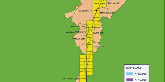
Preparing for earthquakes means getting as much information as you could regarding earthquakes. Good thing that the Philippine Institute of Volcanology and Seismology (PHIVOLCS) is active in its information campaign. Providing the Marikina Fault Line maps is part of that information campaign.
I posted about the index maps of the Marikina Fault Line. However, those are not adequate to answer the question of many readers of this blog. So, to help you and other people like you want to know more about the Marikina Fault Line I will be posting the detailed (large scale) Marikina Fault Line maps.
For this article, I will be posting about the Marikina Fault Line map in the Alabang area:
Based on this Marikina Fault Line map from PHIVOLCS, the fault line passes through the following areas:
Liberty Homes
New Alabang Hills Village
Capri Condominium
Pleasant Village
Lake View Homes
Freedom Hills
The red line on the above map indicates the location of Marikina Fault Line. Here is the explanation of the type of lines used in the map:
Liberty Homes
New Alabang Hills Village
Capri Condominium
Pleasant Village
Lake View Homes
Freedom Hills
The red line on the above map indicates the location of Marikina Fault Line. Here is the explanation of the type of lines used in the map:
The map that I posted here is just a portion of PHIVOLCS Marikina Fault Line map covering Alabang, Muntinlupa City. If you want to view the whole map, I suggest that you visit PHIVOLCS website for the Marikina Fault Line map in Alabang, Muntinlupa.
---
Be prepared for earthquakes! Know more about the Marikina Fault Line by visiting these articles:
PHIVOLCS Fault Line Map for Taguig City and Makati City
Areas Affected by Big Earthquake of the Marikina Fault Line
New Index Map of the Marikina Fault Line
Map of Areas Affected by the Marikina Fault Line
How to be Prepared for Earthquakes
.


