Showing posts with label earthquake. Show all posts

Tuesday, July 29, 2014

New Index of Marikina Fault Line Map

I noticed that there is a new update to the website of the Philippine Institute of Volcanology and Seismology (PHIVOLCS). This update brought both good news and bad news not only to me but to everyone who wanted to get plenty of information about the West Valley Fault, or more popularly known as the Marikina Fault Line.

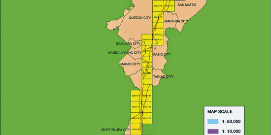
The good news is that they replaced the old index for Marikina Fault Line maps (which you can check on this blog post) with a better looking one:

Marikina Fault Line Map - top
Marikina Fault Line Map - middle
Marikina Fault Line Map - bottom
Index of Marikina Fault Line map (Source: PHIVOLCS website)


The new index map is colorful and gives a clearer overview of the areas affected by the Marikina Fault Line.

The new index map shows that the Marikina Fault Line passes through the Bulacan towns of Doña Remedios Trinidad, Norzagaray, and San Jose Del Monte City; Rizal town of Rodriguez (Montalban);  Metro Manila cities of Quezon, Marikina, Pasig, Makati, Taguig, and Muntinlupa; Laguna towns of San Pedro,  Biñan, Santa Rosa City, Cabuyao, and Calamba City; and the Cavite towns of General Mariano Alvarez, Carmona, and Silang.

The bad news is that the large scale Marikina Fault Line maps are gone. They can not be viewed on the PHIVOLCS website. I am not sure if the link to the maps was just broken or the PHIVOLCS people removed the maps intentionally.

We do not know if PHIVOLCS will return the maps or not.

It is good that PHIVOLCS improved the map index but that improvement is useless if the more important large scale Marikina Fault Line maps are hidden from the public view.

If PHIVOLCS really want people to be informed about earthquakes and the hazards that they brings then should upload the large scale Marikina Fault Line maps back to their website.

Thursday, September 27, 2012

A List of PHIVOLCS Fault Line Maps

The map is the best medium that can be used in presenting geographic information. By just looking at a map, we can know the location of a place, an object or any other thing that can be located on the face of the Earth.

The Philippine Institute of Volcanology and Seismology (PHIVOLCS) knows the usefulness of maps that is why the agency generates maps that contain information related to seismic and volcanic activities. PHIVOLCS teamed up with Kyoto University to create maps that shows the location of fault lines in the different parts of the Philippines.

The location of fault lines was determined using images obtained via aerial photography. Satellite images were also used. The final PHIVOLCS fault line maps were plotted on the 1:50,000 scale topographic maps produced by the National Mapping and Resource Information Authority (NAMRIA).

PHIVOLCS fault line maps are available from the agency's website.

Unfortunately, only some parts of the Philippines are covered by PHIVOLCS fault line maps. The agency is still in the process of collecting data that can be use in the creation of the fault line maps.

Here are the areas covered by PHIVOLCS fault line maps, as viewed on the agency's website on September 26, 2012:

1. Northern Luzon area, which includes Laoag City (Click here to see the map)
2. Central Luzon area (Click here to see the map). This area is covered by 6 map sheets.
3. Infanta, Quezon (Click here to see the map)
4. Guinayangan (Click here to see the map)
5. Bondoc Peninsula (Click here to see the map)
6. Masbate Island (Click here to see the map). this area is covered by 4 map sheets
7. Leyte Island (Click here to see the map)
8. Eastern Mindanao (Click here to see the map)

Take note that the PHIVOLCS fault line maps are in PDF.

Saturday, September 1, 2012

PHIVOLCS Fault Line Map for Samar Island

Do you have questions about fault lines in Samar? Ask me directly by following my Facebook page and leaving a comment or message.

Yesterday (August 31, 2012), an earthquake struck under the sea about 33 kilometers east off the coast of Samar Island. According to United States Geological Center (USGS) the earthquake had a magnitude of 7.6. Tsunami warning were raised for the countries around the Pacific Ocean, which includes the Philippines. Samar was the island that is closest to the epicenter of the earthquake and have the highest risk if tsunami waves were formed.

Thankfully, the earthquake did not generate tsunami waves. Another thing to thank for is that the earthquake did not occur on Samar Island. Much damage might occur if the epicenter of yesterday's is located on land.

There is still a possibility that the next earthquake will occur on Samar Island. Yesterday's earthquake should serve as a reminder to the people of Samar Island that they need to be prepared for calamities due to earthquake.

Philippine Institute of Volcanology and Seismology (PHIVOLCS) prepared maps showing the location of active faults and areas susceptible to liquefaction. Here is the “Active Faults and Liquefaction Susceptibility Map” for Samar Island:
.
PHIVOLCS Fault Line Map of Samar Island

This map was extracted from PHIVOLCS' “Active Faults and Liquefaction Susceptibility Map of Region VIII” The link points to a PDF file.

Here is the legend for the map:
.

Notice that the fault lines on Samar Island can be categorized to three groups, which are the Northern Samar Lineament, Central Samar Lineament and the Southern Samar Lineament.

Notice that the fault line of Central Samar Lieneament passes through Catbalogan City. Those who live in this city should prepare for the possible occurrence of earthquake.

Preparation is the key to safety. I have a blog post that have tips about being prepared for earthquakes and tsunamis.

---

Some information on this blog post was obtained from GMA News website and PHIVOLCS website.

Friday, August 5, 2011

PHIVOLCS Liquefaction Susceptibility Map

In the previous post, I talked about the dangers of landslides that usually occur during earthquakes. Because of the dangers of landslides, PHIVOLCS created Earthquake-induced Landslide Susceptibility maps to help the public know which laces in the Philippines are under the risk of landslide. Another effect that may result from earthquake is liquefaction.

Liquefaction is a phenomenon where the soil that has mixture of liquid, which the usual example is underground water, act like a liquid because of intense shaking caused by earthquakes. Liquefaction usually occurs in places that have During an earthquake, the soil became separated because of shaking and water will come in to fill the gaps between soil particles. Because of this, soil will act like a fluid and will cause the structures on it to sink. Liquefaction usually occurs on areas where the ground is saturated with groundwater or salt water coming from the sea.

The effect of liquefaction is grave, that's why PHIVOLCS created the Liquefaction Susceptibility Map. However, unlike the other maps from PHIVOLCS, Liquefaction Susceptibility Map has only two maps. One is a general map that covers the whole Philippines. The other Liquefaction Susceptibility Map covers Metro Manila and vicinity.
.
Metro Manila Liquefaction Susceptibility Map created by PHIVOLCS
Metro Manila Liquefaction Susceptibility Map.

According to PHIVOLCS map, the areas in Metro Manila that are high risk from liquefaction are the City of Manila and the areas in Pasig City located beside Laguna Lake. Areas that have moderate risk from liquefaction are areas beside the Manila Bay, Laguna Lake and Marikina River. Areas on “higher” elevation, like Quezon City, have low risk of experiencing liquefaction.

Soil liquefaction is an important factor to consider when buying real estate properties. You must ensure that the land that you are buying is safe from this phenomenon. If you are already owning a lot located on an area that is at risk from liquefaction, then you must make sure that the house or structure that you are building on it are “liquefaction-proof.”

For more information, see the liquefaction susceptibility maps on PHIVOLCS website.

Wednesday, August 3, 2011

PHIVOLCS Landslide Susceptibility Maps

The Philippines is still waiting for the so-called “big one,” which is a strong earthquake that will be generated by the long-overdue Marikina Fault. PHIVOLCS is doing the necessary preparations for earthquakes. The agency also reminds the public to be prepared.

Aside from the earthquake, PHIVOLCS is also reminding the people about the possibility of landslides during and after an earthquake occurred. As a part of preparation schemes, PHIVOLCS prepared the “Earthquake-triggered Landslide Susceptibility Map.” This map shows how susceptible an area in the Philippines are from landslides.

Based on the overview map that is available on the PHIVOLCS website, the areas that are high risk for earthquake-triggered landslide are mountainous areas like the Cordilleras.
.
PHIVOLCS earthquake-induced landslide susceptibility map

View the “Earthquake-triggered Landslide Susceptibility Map” on PHIVOLCS website.

The map is shaded in different colors and every color has different meanings. The gray shade means that the area is not susceptible to earthquake-triggered landslide. Areas in green shade means that at risk to landslide at 0.3 MMI-IX and PEIS-VIII. Areas in orange shade are at risk from landslide at 0.15 MMI-VIII and PEIS-VIII. Areas in magenta are at risk from landslide at 0.07 MMI-VII and PEIS-VII. Lastly, areas in red shade are at risk from landslide at 0.04 MMI-VI and PEIS-VI.

MMI stands for Modified Mercali while PEIS stands for PHIVOLCS Earthquake Intensity Scale.

Aside from the overview map, PHIVOLCS also has Regional Maps of the “Earthquake-triggered Landslides Susceptibility Map” for regional and better view of the landslide prone areas.

The “Earthquake-triggered Landslide Susceptibility Map” and regional maps can be downloaded on PHIVOLCS website.

Read related posts about PHIVOLCS Tips on what to do before, during and after an earthquake.

Other related posts are:


---

Tuesday, March 22, 2011

PHIVOLCS Maps of Marikina Fault Line Affected Areas

PHIVOLCS is calling all owners of buildings and structures located on or near the Marikina Fault, which is now officially named as West Valley Fault, to be prepared as an earthquake may strike along Marikina Fault at any time. According to PHIVOLCS, the latest activity of Marikina Fault occurred at around 200 years ago and the accumulated stress will cause a major tectonic activity.

Yesterday, March 21, there is an earthquake that occurred off Lubang Island. It seems like that there is a rise of occurrence of felt earthquakes around the Philippines. Thus, it is no wonder that PHIVOLCS is anticipating movement of the Marikina Fault.

Due to this, many people are afraid of a major earthquake along Marikina Fault. Thankfully, PHIVOLCS drew maps of Marikina Fault, which shows where the fault lines are. Based on a PHIVOLCS document (Pdf file), Marikina Fault passes through Laguna, Muntinlupa City, Quezon City, Montalban (Rodriguez) Marikina City, San Mateo, Pasig City and Taguig City. Here is the diagram as shown on the document issued by PHIVOLCS:
.
Diagram of Marikina Fault Line map


Here is a rough map showing the general location of Marikina Fault Line in Metro Manila:
.
Rough Marikina Fault Line map
Rough map showing the areas affected by Marikina Fault.

Visit PHIVOLCS website to see the maps of areas affected by Marikina Fault. PHIVOLCS has 15 large scale maps, which is helpful in seeing if your home is near the Marikina Fault or not.

Map is obtained from the document, The Marikina Valley Fault System: Active Faulting in Eastern Metro Manila (Pdf file), as posted on PHIVOLCS website.

Also read related post about the PHIVOLCS Tips on what to do before, during and after an earthquake, PHIVOLCS list of fault lines and PHIVOLCS Map of Tsunami Prone Areas.

---

Do you have questions about the Marikina Fault Line? You have comments about the earthquakes and how prepared our government for such calamities? Tell me about it by leaving a comment.

Monday, March 14, 2011

Information on Fault Lines and Earthquakes from PHIVOLCS Fault Finder Map

The calamity that occurred in Japan last Friday sparked the attention about the safety of the Philippines about earthquakes and tsunamis. PHIVOLCS and the government assured that the new high-rise buildings around Metro Manila are sound enough to withstand earthquakes. However, many people are still concerned, especially because of the many fault lines around our country.

For those who are looking for a map issued by PHIVOLCS that shows the major fault lines, I suggest that you visit the PHIVOLCS Fault Finder map. The Fault Finder map shows the distribution of active faults and trenches in the Philippines as delineated by PHIVOLCS. The picture below shows the general location of fault lines and trenches. The Fault Finder map of PHIVOLCS is much clearer and interactive so I suggest that you should look at it.
.

PHIVOLCS Philippine Fault Line Map


 .

To see the regional distribution of fault lines in the Philippines, I suggest that you also look at the Fault Finder map of PHIVOLCS.

Be prepared for earthquakes and the best preparation is to gain knowledge.

Visit my posts about PHIVOLCS Tips on what to do before, during and after an earthquake, PHIVOLCS Map of Tsunami Prone Areas, and PHIVOLCS Maps of areas affected by Marikina Fault.

---

Do you need information about PHIVOLCS? Do you have questions regarding earthquakes and fault line maps? Please tell us by leaving a comment.