Previously, I posted about the portion of Marikina Fault Line that passes through Alabang, Muntinlupa. That post contained a map from the Philippine Institute for Volcanology and Seismology (PHIVOLCS) and a short list of places that were traversed by the fault line.
Now, let us see another area in Metro Manila that is affected by the Marikina Fault Line. This area is the city of Taguig and the southern portions of Makati City.
Now, let us see another area in Metro Manila that is affected by the Marikina Fault Line. This area is the city of Taguig and the southern portions of Makati City.
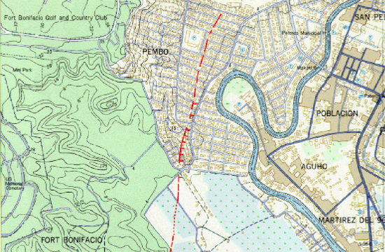
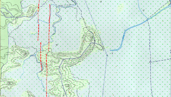
According to this PHIVOLCS fault line map, the Marikina Fault Line passes through the following areas in Taguig City:
1. Barangay North Signal Village
2. Area between Maria Reyna ng Apostoles Church and Heritage Park
3. Barangay Pinagkaisa
- Sto. Niño Village
- Wildcat Village
- Palar Village
The Marikina Fault Line crossed the boundary of Taguig and continued to Makati City in these areas:
1. Barangay Rizal
3. Barangay Pembo
- Area just east of Pembo Elementary School
The red lines on the PHIVOLCS fault line map above indicate the location of the Marikina Fault Line. To better understand the meaning of the red lines, please read this legend:
The map I posted here can be viewed and downloaded from the PHIVOLCS website. In addition to the PHIVOLCS fault line map, I also used Google Maps and Wikimapia data for this post.
It is scary to know that your house or workplace sits on or near the Marikina Fault Line. The fear is compounded by the fact that PHIVOLCS said that the Marikina Fault Line is ripe for movement. This means that a big earthquake will happen any time.
I hope that the city governments of Taguig and Makati take a serious preparations for the big earthquake. Residents, for their part, should also do some preparations like strengthening their homes or moving to another place that are far away from the Marikina Fault Line.
---
Do you wish to know if your house stands on or near the Marikina Fault Line? I suggest that you read the following posts:
PHIVOLCS Fault Line Map for Alabang, Muntinlupa City
Index Maps of Marikina Fault Line
Areas Affected by the Big Earthquake of the Marikina Fault Line
You should also read PHIVOLCS’ tips on how to be prepared for earthquakes.
I also recommend Nababaha.com’s map of Marikina Fault Line because it overlaid the fault line on Google Maps.
.


